FL Everglades Challenge Registration SPOT Setup
Tampa Bay To Key Largo In Sea Kayaks, Canoes and Small BoatsThe next Everglades Challenge is Saturday, March 2, 2013. There is an equipment inspection on Friday, March 1, 2012. Cost is $395 for the captain and $395 for a crew member if any. Billing starts January 1. Registration ends January 31 at noon. Payment Deadline is January 31 at noon. |
WT Event Charity Links |
Completion of an Everglades Challenge within the last Ultimate Florida cycle satisfies the entrance requirement for the Ultimate Florida Challenge. For example, completing EC2010 or EC2011 allows entrance into UF2012.
Due to the exteme commitment for this race late registration and/or late payments will not be allowed. We recommend that you commit to this race early so you have plenty of time for planning, training, and preparation. Pay early in the payment cycle. You can get a full refund up until January 31 at noon. No refunds after that date and time.
All WaterTribe events are dangerous events as defined by Florida law and common sense. You are responsible for your own safety. You must read and understand The Rules and Warning before you register for this event.
The Everglades Challenge is an unsupported, expedition style adventure race for kayaks, canoes, and small boats. The distance is roughly 300 nautical miles depending on your course selection. There is a time limit of 8 days or less. Your safety and well being are completely up to you.
Unsupported means that there are no safety boats or support crews to help you during the race. You are not allowed to have a support crew follow you or meet you during the race. It is OK to have family or friends meet you at the official checkpoints, but they cannot provide anything other than emotional support. See the official WaterTribe rules for more details.
Expedition style means that you must carry the same type of equipment and supplies that you would carry on a major expedition lasting 4 weeks or more. Camping equipment, food, water, safety, communication, etc. is required. See the official required equipment list for more details.
Although this is a race, many participants are more interesting in cruising and adventure. Whether you are a cruiser or racer is up to you. Just getting to the starting line is a major accomplishment and only about 40% of starters are able to finish. You should be an expert kayaker and/or sailor before you consider this challenge.
SPECIAL NOTE 1: You can earn an alligator tooth award by completing the entire Everglades Wilderness Waterway between Chokoloskee and Flamingo. There are specific rules for earning that tooth:
- You must obey all Everglades National Park rules.
- SPOT must be correctly used at all times.
- You must complete the entire WW as shown on their official maps. You can exit at Broad River and return via Broad Creek. Using the Harney River from the outside is not allowed.
- The Nightmare is an option. Some people say that taking the Nightmare is easier than negotiating Broad Creek from the entrance. The choice is yours.
- Once you have reached Whitewater Bay you may follow the marked route or take the Joe River or any other route to cross the bay and enter Tarpon Creek and the Buttonwood Canal.
- In some years challengers have taken the Hells Bay Canoe Trail to Tarpon Creek. Since this is marked on the official map, it is also OK.
- You must portage your boat a short distance between the fresh water side and the salt water side at Flamingo. You cannot receive assistance from the Race Manager, CP Captain, or bystanders. Challengers participating in the event may assist other challengers (see the note below).
SPECIAL NOTE 2: In some previous years we have provided a boat cart or other assistance for the short portage at Flamingo. As of EC2011 a boat cart will not be provided and all challengers crossing from the fresh water side to the salt water side must do this short portage without outside assistance. No cart will be provided. You must carry your own if you plan to use one. If bystanders want to help they cannot. However, other WaterTribers who are in the same event can help - see the ad hoc team rule.
The Everglades Challenge follows the SW Florida coast line from Fort Desoto in Tampa Bay, Florida to Key Largo. You will enter Everglades National Park near Everglades City and you will be within their boundries until you get near Key Largo. You must follow all park rules and regulations.
Note that the WaterTribe Marathon runs concurrently with the Everglades Challenge. The schedule mentions both races.
Schedule
Note that the WaterTribe Ultra Marathon runs concurrently with the Everglades Challenge. The following schedule mentions both races.
Gear Inspection - Friday, March 1, 2012 Is Mandatory.
Race - Saturday, March 2, 2013 to Sunday, March 10, 2013.
| Locations | Deadlines | Notes | |
|---|---|---|---|
|
Captains Meeting Gear Inspection |
Tampa Bay Fort Desoto East Beach Shelter 13 |
Gear & Boat Inspection Friday 10:00-15:00 Captains Meeting Friday 15:00-17:00 |
Attendance Is Mandatory For those who cannot make this meeting, other arrangements can be made. Contact mailto:Chief@WaterTribe.com |
| Start: |
Tampa Bay Fort Desoto East Beach in front of Shelter 13 |
Assemble Saturday 05:00-06:30 Last Shuttle Saturday 06:15 Roll Call Saturday 06:30-06:45 Launch Saturday 07:00 |
Start for Challenge and Marathon |
|
Finish: and CP1: |
Grande Tours Placida, FL |
Ultra Marathon Award Deadline Sunday Noon Challenger Deadline Sunday Noon |
WaterTribe Ultra Marathon Finish Line CP1 for Everglades Challengers As of EC2008 both UM and EC particiapants must get to CP1 by noon Sunday. |
| CP2: |
Outdoor Resorts Chokoloskee, FL |
Wednesday 10:00 | Challengers Only |
| CP3: |
Yacht Basin Flamingo, FL |
Friday 10:00 | Challengers Only |
| Finish: |
Bay Cove Motel Key Largo, FL |
Award Dinner Saturday Time TBA Deadline Sunday 07:00 Departure Sunday 10:00 |
WaterTribe Everglades Challenge Finish Line |
Start - Fort Desoto Park, Tampa Bay, Florida
The race will start in Fort Desoto Park (the link shows a nice bird's eye view of the starting beach) located on Mullet Key in Tampa Bay, Florida. A large pavilion is reserved for all day Friday. Boats may assemble on the adjacent beach. All boats should be left on the beach above the high water mark Friday night. A guard will be posted.
The pavilion is at East Beach on the eastern leg of Mullet Key facing south. There is a very nice beach perfect for launching boats. There is road access to the beach for sailboats. See the Chief at the captains meeting for directions.
Friday afternoon there will be a captain and crew meeting which is mandatory. Your boat may be inspected for final class determination. If you can't make it to the normal equipment inspection on Friday, you should arrange another time. Email Chief (Chief@WaterTribe.com) to make special arrangements well in advance.
If you don't want to off load your boat right on the beach, there is a very nice boat ramp on Mullet Key. After you pass through the toll booth ($0.35 per car + $0.10 per axle) and go over the bridge, the ramp is on your right. Many cars are parked here for days at a time for extended fishing trips. This is where you will leave your car and trailer if you don't get someone to drive it down to Key Largo. The lot is patrolled. Please note that none of us associated with the race accepts any responsibility for your vehicle or trailer or their contents.
After you launch, you can sail around Mullet Key to the pavilion. The Lat/Lon of the pavilion and the beach adjacent to it will be provided in due course.
Camping on Mullet Key
There is a very nice campground on Mullet Key.
- Sites 1-85 are designed for tent, van, and pop-up campers.
- Sites 86-233 are designed and equipped to accommodate all camping units
- All sites have water, electrical hookup ( 30 amps), picnic table, and a charcoal grill
- Dump stations, restrooms, showers, and laundry are available
- Many sites are waterfront with room for your kayak or boat in your camp site.
Reservation is VERY limited. Reserve your site as early as possible. Google Fort Desoto park for reservation information.
CP1 - Grande Tours, Placida, Florida
Roughly 60 miles along the coast from Tampa Bay you will come to Boca Grande Pass into Charlotte Harbor. The Grande Tours checkpoint is located a few miles north of the pass at Placida, Florida adjacent to the inland waterway Placing the checkpoint north of Boca Grande means that you will have a "safe haven" to wait out the weather if the pass is dangerous. If you're not too tired and the conditions in the pass are good, just check in, cross the pass, and camp at Cayo Costa. But if conditions are bad or you are not in condition to continue, you will have a nice place to stay and recover or wait for weather to clear.
Finding Grande Tours
Grande Tours is tucked just a bit out of the way from Intercoastal as you approach the Boca Grande area. You will need your chart to interpret these directions. I'm using Maptech Number 31 Edition 1.
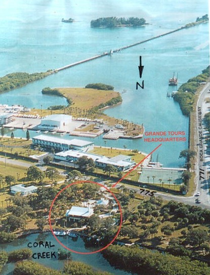
Click to get larger views. Thanks SansSouci. An aerial shot of Grande Tours. The always open railway bridge is shown. Looking south. The swinging bridge is just out of the picture on the right side. Contact and Operating Info: Open 7 days 08:30 to 16:00; Note that during a challenge WaterTribe has full use of the restroom facilities. Grande Tours has kayaks for rent, eco tours, bikes, and nice pontoon boats that make stable photography platforms. Access to Grande Tours is easy. Just find Placida north of Boca Grande pass on a Florida map and go there. They are very close to the corner of 775 and 771 on the east side of 775. Grande Tours |
Thanks AndrewsCanoes Here is another view showing the route in red. |

If you approach the area from the outside you will see the fixed bridge as you enter Gasparilla Pass. Unfortunately there isn't a clearance gauge on the bridge pilings so you will have to eyeball the clearance. Bird Key offers a beach that you can use if you need to step your mast. Stay on the causeway side of Bird Key or shoals will get you. Kayakers -- no problemo. You can also pass between Bird Key and the causeway and go on down to the swinging bridge between Placida Harbor and Gasparilla Sound. There are two clearance gauges here one for the lowest point of the bridge (left side of southbound channel) and one for the highest point of the bridge (right side of southbound channel). Note that the swinging bridge has a south bound channel and a north bound channel. My sailing kayak would be able to scoot under the highest part of the bridge at low tide but not at high tide. It all depends on mast height.
After you get by the bridges you have to pass through the old railway bridge. This section is always open since the rail system isn't used any more.
Just after you pass through the railway cutout you will see two channels on your left. Take the second channel. They aren't very far apart. The channel is off the Intercoastal flashing red marker number "20". The channel leading to your left will have markers "1 green" and "2 red" but remember, it's the SECOND channel leading to the left. The first channel has the same numbers so it's easy to get confused especially at night.
Follow the second channel almost to the marina that you see dead ahead but turn left just before you enter the marina.
While paddling in using the second channel, keep looking left and you will immediately see a low bridge. Vertical clearance is only about 6 to 8 feet. The distance between the 771 bridge pilings is about 12 feet. Grande Tours has a couple of pontoon boats that are 10 feet wide that go through all the time. Squeeze between the bridge pilings and you will see another spur of railroad ending in the water. Go around the end where there is a channel, but STAY CLOSE TO THE END OF THE RAILROAD BRIDGE. There are some nasty pilings just under the water on the right side.
Now stay close to the left bank of mangroves. Not too close or you will run aground. But not too far away either or you will run aground. the channel isn't marked but stay 10 to 15 yards off the left bank and you should be OK. This whole area has lots of oyster bars. Be careful if you have an inflatable or a pretty boat.
Grande Tours is less than 5 minutes from the railroad spur. Bear left always. If you go to the right you will get lost.
From the Intercoastal after the swinging bridge it only takes 15 to 20 minutes to get to Grande Tours, and I was lollygagging.
Fresh Water
Grande Tours has fresh water available. They also have an outdoor shower, restroom, a bunkhouse, and a bivouac area.
Physical Check In Station
An ORANGE LOCKBOX will be located on the picnic tables next to the canoe ramp at Grande Tours
In the ORANGE LOCKBOX you will find a logbook. You must sign the logbook and fill out each section adjacent to your name.
Landing Waypoints for Grande Tours and Cayo Costa
The canoe landing at Grande Tours is on a deep water channel just around the corner from the intercoastal waterway.
| Lat/Lon Checkpoint 1 Grand Tours Kayak Landing 026° 50.13 N The lockbox is on a picnic table next to the landing. |
The outside north end of Cayo Costa has a nice beach that is usually easy to land on. If the weather is contrary, you may also pull in on the inside of the island.
| Lat/Lon of Cayo Costa Beach Landing 026° 41.21 N This at the beach in front of the campground. Due to surf conditions you may have to pick a different landing point. Just up the beach from this point you will find the next position given below. |
| Lat/Lon of Cayo Costa Campground Trail 026° 41.21 N This point is standing on the beach just at the start of the trail leading into the campground that passes right by the restroom. |
Accommodations at Grande Tours
There is plenty of room to pitch tents as needed.
The canoe landing shows attention to detail. The bivouac area would be to the right in this picture in front of the pontoon boats. |
The rest room is on pilings. There is a wheelchair ramp that spirals to the balcony. |


After Grande Tours Checkpoint
Crossing Boca Grande and Cayo Costa Camping
Some challengers may want to leave noise and activity at CP1 and cover a few more miles before camping at Cayo Costa. The following is for information only. There are no checkpoints at Cayo Costa.
Tide Rips
There is a very strong tide into and out of Charlotte Harbor through Boca Grande pass. If you are close to shore, be sure your ferry glide technique is perfect. In some places I've been traveling backwards while paddling as if my life depended on it. If you are a little outside, the current is not as strong but be advised.
Big Fish and Big Boats
Boca Grande Pass is famous for tarpon fishing. Stay well away from large groups of boats that are fishing the pass. They don't give a darn about you and they have a short temper. Also, watch for boats "drifting" through the pass. They are worse. Also, watch for boats running the pass to get to the head of the drift line. They are the worst. The bottom line is -- be careful. Many kayakers traverse this pass all the time so I don't mean to be an alarmist. Just be alert.
Did I mention tide races and rough water?
Cayo Costa Ranger Station
If you decide to take the inside route, you can land at the ranger station. Note that from any distance it is difficult to see the ranger station from a kayak. There is usually a group of boats anchored between Cayo Costa and an adjacent mangrove island called Punta Blanca Island. If you are paddling down the inside of Cayo Costa, you can't miss it. There isn't apublic phone at Cayo Costa.
| Lat/Lon of Cayo Costa Ranger Station Dock 026° 41.16 N This point is standing on the dock in front of the ranger station. |
| Lat/Lon of Cayo Costa Ranger Station Landing for Kayaks and Canoes 026° 41.17 N From the ranger station dock look to your right and see a small inlet with a wooden boardwalk/dock on the left side and mangroves on the right side. This is a short inlet -- maybe 50 yards long. Just a bit before the inlet comes to a dead end look on the right side for a small sign indicating the kayak and canoe landing. After landing, follow the trail around to your left to get to the ranger station. A little further and you will find a restroom. The wide road in front of the restroom leads straight to the campground. Don't take any turns along the path at night or you will get lost. |
If you land on the ranger station side, you will have to carry all your gear over to the other side of the island for camping. There is a tram available but it only runs a few times each day. In the 2001 Challenge some racers were allowed to bivouac at the canoe landing, but don't count on it.
Fresh Water at Cayo Costa
Fresh water is available at Cayo Costa. In the campground on the beach side of the restroom building you will find a shower. On the opposite side of the building you will find a wash tub and a spigot. The water is fresh and potable. If you are particular about taste, you might want to filter it.Many people clean fish in this area.
Be Quiet At Night
If you come in at night, be respectful of the other campers and the rangers. Be as quiet as possible while setting up your camp. The other people in the campground are looking for peace and quiet. If we disturb them, we may not get to use this checkpoint in future events. But on the other hand don't expect all the campers to be quiet for you. You may end up next to a bunch of party animals.
CP2 - Chokoloskee, Everglades National Park, Florida
Roughly 70 miles along the coast from Cayo Costa you will come to Indian Key Pass. The mangrove channel that leads to the fabled Everglades City. You are at that crucible that will weed out the Men from the boys; the Women from the girls; and Real Boats from mere puddle hoppers.
Tide Will be a Factor
There are strong tidal currents through these mangrove channels that can make grown men cry. A huge amount of water flows through these channels so current can be 2 to 3 knots or so.
Another interesting phenomenon is that as the water level drops or rises various sand/mud/oyster bars are exposed or covered. Flow changes and currents become counter intuitive.
Tide tables and local knowledge of how to interpret them will be published long before the race. Don't get too fixated on the tide problem right now. If the tide is too strong, you have two basic choices: wait or paddle harder.
I plan to pitch my hammock on Indian Key, or thereabouts, and nap until the right time.
It Is Doable
Having warned you of the terror, I must remind you that this is a doable entrance that is used by kayaks, canoes, sail boats, and motor boats all day long almost every day. Some of our discussion forums have gotten carried away with the difficulty of this checkpoint -- thus the opening paragraph.
If you use Indian Key Pass to enter Everglades City and then use Chokoloskee Pass to exit Everglades City, you will minimize tide issues and the need for local knowledge. These two channels a wide enough and well marked so as to be considered "normal" navigation and difficulty.
Some plan to take a detour and visit Watson's Place instead of take Chokoloskee Pass. This too should not present any difficulty for classes 1 and 2, but classes 3 and 4 may want to think real hard about trying this route.
Big Boats Are Everywhere
Big boats are cruising these channels so watch out. Some of them run at night with no lights. If you must travel these channels at night, keep lots of lights going on your boat and keep a strong spot light handy.
Access for Family and Friends
This is a regular city on the west coast of Florida with highway access. There is an article in the Sept/Nov 2000 issue of Paddler Magazine about Everglades City.
The resort of choice in this area is Outdoor Resorts of America, Inc. located at the entrance to Chokoloskee Island. They have RV campsites and cabins along with full services. Their public restroom at the docks was the cleanest I've seen at a public spot in a long time. Their phone number is 1-941-695-2881
Fresh Water
Fresh water is available at Everglades City as well as restaurants, convenience stores, and kayak outfitters. Your best bet is the hose at the canoe ramp at Park HQ or the hose at the docks of Outdoor Resorts or the convenience stores at both locations. Beware however that availability of bottled water at these two convenience stores is not guaranteed. There are other stores in the area within about a 1 mile radius at both locations.
The hoses will be easily accessible, but I recommend that you filter all water from hoses -- if only for taste.
Everglades Park
This is the North Headquarters of Everglades Park. If you are taking the inside route, you must register with the park rangers. If you are taking the outside route, you may have to register with the park rangers. It depends on whether or not you intend to camp on the way to Flamingo.
Everglades National Park
When you reach Everglades City, you are about to enter the Everglades National Park. You must follow all park rules and regulations. Depending on your chosen course (inside or outside) and whether you will have to camp on the way to Flamingo will determine if you must obtain a Wilderness Permit . This is entirely up to you and your decisions about your best course.
You can get more information directly from the park at the following:
- 1-305-242-7700 ask for a Wilderness Trip Planner
- visit www.nps.gov/ever
You will have to get your permit when you arrive at the Everglades City/Chokoloskee checkpoint. They are open normal business hours so you may decide to check in first and then go to the ranger station or the other way around. It depends on what time you arrive.
In most cases, the outside route will be faster, but your open water skills must be up to the challenge. This is during the busy season so have two or three alternate sites in mind for your camping permit.
If you don't get a camping permit, you are not supposed to camp. However, there is no rule that I know of that prevents you from stopping for a snack or a break. DO NOT camp without a permit.
Our race IS NOT approved or sanctioned by the park. They couldn't care less that you are in a race. In fact, they may get alarmed if you bring it up. We aren't doing anything illegal by paddling or sailing through as fast as we can, but DO NOT expect any favors from the park. The best course of action is DO NOT mention the race.
Here is my plan. I am going to purchase a Wilderness Permit and pick a campsite roughly half way to Flamingo. If I can't get one half way, my backup is going to be any campsite on Cape Sable. Then along the way I will take a break when I need it. A hammock in the mangroves for a few hours won't bother anybody. No worries.
Remember to practice the Leave No Trace principles during this race and especially while in the park. The Everglades National Park is a unique treasure that we must help preserve.

This is the "canoe ramp" at the Everglades City Park Headquarters. Concrete with some wood slats. Nice huh?
25° 50.72' N
081° 23.23' W
You must come here if you will be camping along the way to Flamingo.
NOTE: This is not the checkpoint. The checkpoint is at Chokoloskee. See below.
If you need significant food or services, you might consider stopping here and walking into Everglades city. If you just need convenience store items, please buy from the resort at the actual checkpoint in Chokoloskee.
Indian Key Pass is a well marked channel. Just before you get to the Barron River make a hard right turn and you can't miss the Park marina. They have a SMALL convenience store and not much else. About 1 mile into town or so you will find a grocery store. Not a big super market but some supplies available. This is your best bet if you need anything serious.
There is a hose at the canoe ramp for fresh water. I recommend a filter if you are particular about taste.
Roughly 3 miles along the causeway you will come to Chokoloskee Island. You can't miss it on the chart. This is your official race checkpoint.
Physical Check In Station
The Chokoloskee check point is at the Outdoor Resorts of America located at the entrance to Chokoloskee Island. You will land on the beach on the west side of the causeway. The resort is located on the other side of the road a stones throw from the beach. Check in with the person running the office. Get your passport signed and make sure your time of arrival is noted on the checkpoint log.
Remember to click on each photo for a larger view.
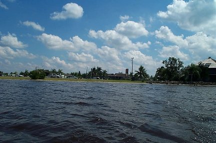
The view of the Chokoloskee check point from the water.
Business hours are 6AM to 6PM.
IMPORTANT: WASH the mud off the first thing you do so you don't mess up the resort. Do this at the far left end of the docks.

The view of the beach after you land at the Chokoloskee check point.
25° 49.08' N
081° 21.57' W
Note that the grass just above the beach will be filled with cars and boat trailers during the race. This picture was taken in the off season. On the left side of the beach where the mangroves stop is a little deeper water. It might make your path through the mud a bit shorter.

Note the mud trail if you land at low tide and have to pull your boat across the mud.
If you land on the left side of the beach next to the mangroves you may have less mud to deal with
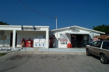
Chokoloskee Mall. Does this give you an idea about the amount of food and other services available? Less than 1 mile from the checkpoint.
The resort has a small convenience store but if they don't have what you need the store shown above is just a bit bigger. Don't expect too much. A larger store is about 3 miles away.


Some different views of the lockbox location. The picnic table is on the dock/ parking lot. All the hoses are city water but you may want to filter just for taste.

The restrooms are in the breeze way by the ice machine. Be sure you have rinsed off any mud before you go in. Keep the restroom clean so we can use this checkpoint again next year.
Please buy as much as you can from their convenience store. This resort has been very helpful and they are doing it free of charge.
The Outdoors Resort at Chokoloskee offers a small convenience store, water, showers, laundry, and an enthusiastic manager, Kenny Brown. The people of Chokoloskee were very friendly and curious about our race. They like kayakers here.
There is no tent camping so if you want to spend the night, you will have to reserve a room. Call 1-941-695-2881 ASAP if you will want to stay here for a night when you check in. This is a very popular area during March. This is a very nice resort and I was amazed at how clean their rest room was when I visited.
Note that tent camping in this area has been driven out by RVs. Most snowbirds come down for several months in the winter and there just isn't room for tents. However, Pavilion Key and other NP camp sites are fairly close. If you absolutely MUST tent camp at this checkpoint, your best bet MIGHT be to find a secluded spot along the causeway and practice a little stealth camping. I have slung my hammock next to their canoe landing.
CP3 - Flamingo, Everglades National Park, Florida
Roughly 60 miles along the coast from Indian Key Pass you will come to Cape Sable. A few miles around the point and you will find Flamingo. This is the Southern campground in the Everglades Park. You're almost home free at this point. The nightmare of Everglades City is behind you and you can almost hear me partying in Key Largo.
Tide Is Still a Factor
Tide is always a factor in a small boat. The tide can be even more difficult here because there are so many factors that enter into it. Fresh water flow from the glades, Atlantic flow, Gulf flow, wind, pressure, channels. The area is very shallow. You really must get chart 33E.
I plan to pitch my hammock somewhere between Middle Cape and Clubhouse beach and take a nap until the time is right.
You've looked at the chart and noted the shallow water. Right?
Big Boats Are Everywhere
Even bigger boats are cruising these waters so watch out. Some of them run at night with no lights. If you must travel at night, keep lots of lights going on your boat and keep a strong spot light handy.
Access for Family and Friends
Flamingo is located on the southern tip of the Florida mainland with highway access.
If You Drop Out
If you drop out at Flamingo, be sure to let the check in crew know. They will help you arrange for transportation to Key Largo. You may have to stay at Flamingo a day or two (hopefully not more) for the transport to show up.
Fresh Water
Fresh water is available at Flamingo as well as a restaurant, convenience store, boat ramp, campground and hotel.
Physical Check In Station
The Orange Lock Box containing your check in logs in chained to a palm tree in front of the Dockmaster's house at the Marina/Store area. You can see the lock between fresh water and salt water as you paddle down the channel from either side.
Lock Combination is as follows: 3 - 1 - 4
Line up all the numbers on the black line.
The same combination is used for all check points. IMPORTANT -- After you log in,
you must lock the box. Be sure to hold the clasp into the lock and the SPIN the
dial. If you do not spin the dial while holding in the clasp, the lock will be open.
Check it before you leave.
|
Lat/Lon of Flamingo Lock Box
025° 08.55 N The box is chained to a palm tree outside the Dockmaster's office. The office is where the sail boats and big boats are docked. (See pictures below.) If you navigate to this Lat/Lon from the water, you will run into the basin concrete wall. Instead, navigate to the canoe landings or the campsite and then find the box. NOTE: The rangers have the combination and could decide to move the box. If you can't find the box, ask the Dockmaster. It could even be in their office. |
|
Lat/Lon of Canoe Landing Bay Side
025° 08.55 N This is a floating dock in the yacht basin. (See pictures below.) |
|
Lat/Lon of Canoe Landing Fresh Water Side
025° 08.56 N This is a floating dock on the fresh water side of the lock. |
Everglades Park
If you haven't already phoned for your Everglades Wilderness Trip Planner, you better do so ASAP.
- 1-305-242-7700 ask for a Wilderness Trip Planner
- visit www.nps.gov/ever
|
Click on each picture for a larger view. |
|

The canoe landing on the bay side. Another landing is on the freshwater side. A portage will be required if you take the inland route. NOTE the roller on the end of the landing. If you use it to pull your boat out and the ends each have 100 pounds of gear, your boat could crack. Thanks to Hellbender for that tip. |

A view of the lock from the fresh water side. You can just make out the canoe landing behind the boat top. Don't even think about using the lock. |

Motor boat ramps. One on each side of the lock. If you use these ramps, your portage will be about 1/4 mile. If you use the canoe landings, your portage will be about 20 yards. |
NOTE: Both landings are used by a commercial canoeing company. If you see them loading or unloading paddlers, defer to them. Wait your turn or you can use the motor boat landings -- one on each side of the lock. |
Finish - Bay Cove Motel, Key Largo, Florida
We will be ending the race at the Bay Cove Motel in Key Largo. You may reserve a room by calling 305-451-1686. Do your family a favor and have them wait for you in Key Largo! Here is a link to some pictures: Bay Cove Motel
The award ceremony will be on Saturday afternoon or evening. Details announced at the captains meeting before the race.
Activities in Key Largo include snorkeling, SCUBA diving, glass bottom boats, flats fishing, deep sea fishing, beaches, shopping, and more. There is plenty for your family to do while waiting for your arrival so book your room for the whole week in advance -- your family will thank you for it and you will be able to do this year after year.
|
Lat/Lon of Bay Cove Landing Beach and Dock
025° 05.585 N |
Rooms are limited so reserve early. It's the place to be.